(CNN)The cyclone Joaquin strengthened into a Category 1 hurricane in the Atlantic on Wednesday morning, poised to pound the central Bahamas with heavy rain and dangerous storm surges in the next day.
Its move after that -- still hard to predict -- could have flooding implications for an already drenched eastern United States.
Joaquin's center was spinning 190 miles (305 kilometers) east-northeast of the central Bahamas. Its maximum sustained winds of 85 mph (130 kph) were mid-range for a Catergory 1 storm, but forecasters predicted it would become stronger.
A hurricane warning was in effect for the central Bahamas, with the storm's center expected to be near or over the islands by Thursday before turning north, the U.S. National Hurricane Center said.
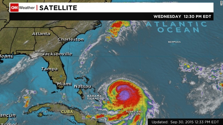
A satellite image shows Hurricane Joaquin in the Atlantic Ocean, west of the Bahamas, on Wednesday afternoon.
More than 10,000 people live on the Bahamian islands most squarely in the storm's path. Five to 20 inches of rain could fall over much of the central Bahamas through Friday, with lesser amounts expected over the rest of the country, the center said.
"Preparations to protect life and property should be rushed to completion," the hurricane center said about the Bahamas on Wednesday.
Hurricane Joaquin is lifting storm stocks
Rain and winds aren't the only concerns: Dangerous storm surges -- with water levels as high as 4 feet above normal tides -- are possible on the Bahamian coasts.
Swells from Joaquin also will affect the southeastern U.S. coast by Friday, potentially creating life-threatening rip currents, the hurricane center said.
A U.S. landfall?
A hurricane hasn't made landfall in the eastern United States since Hurricane Arthur hit North Carolina in 2014. That could change with Joaquin.
Forecasters expect Joaquin to turn north after the Bahamas, but they have low confidence in predicting the path after that. Many U.S. computer forecast models predict a hit on the East Coast next week, anywhere from North Carolina to New York's Long Island.
One European-based model predicts the storm going out to sea instead.
"We simply don't know if it's going to go left into America or right and pass Bermuda," CNN meteorologist Chad Myers said.
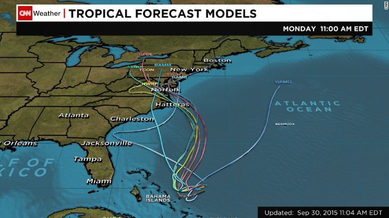
Many computer forecast models predict U.S. landfalls for Joaquin by next week.
The hurricane center said Joaquin could become a Category 3 hurricane, with winds of 115 mph, in the Atlantic Ocean by Saturday after leaving the Bahamas. However, forecasters expect the hurricane to weaken and revert to a Category 2 shortly after that, the center said.


|
Blue Acres Buyout Application.pdf Size : 100.176 Kb Type : pdf |
|
|
Flood Gate Study Timeline.pdf Size : 331.341 Kb Type : pdf |
|
|
USACE study which clearly talks about the flow reversal of the Passaic River.pdf Size : 497.701 Kb Type : pdf |
|
|
Flood Damage Reduction and Restoration Projects.pdf Size : 83.829 Kb Type : pdf |
|
|
2010 to 2011 FEMA rules for buyouts instruction manual.pdf Size : 888.912 Kb Type : pdf |
|
|
Stormwater and Nonpoint Source Pollution.pdf Size : 140.484 Kb Type : pdf |
|
|
Briefing with Passaic River Basin Flood Advisory Commission.pdf Size : 2367.034 Kb Type : pdf |
|
|
PSYCHOLOGICAL FIRST AID.pdf Size : 3456.105 Kb Type : pdf |
|
|
Dredging projects.pdf Size : 10.753 Kb Type : pdf |
|
|
Fairfield Childrens Letters.pdf Size : 350.976 Kb Type : pdf |
|
|
Annual Report from 1905.pdf Size : 12274.228 Kb Type : pdf |
|
|
FCFCR- Brochure.pdf Size : 22.088 Kb Type : pdf |
|
|
Fairfield Flood Tour.pdf Size : 3608.443 Kb Type : pdf |
|
|
passaic-report201101.pdf Size : 3276.362 Kb Type : pdf |
|
|
Raritan River Dredging.pdf Size : 190.813 Kb Type : pdf |
|
|
How to read river gauges.pdf Size : 1486.568 Kb Type : pdf |
|
|
2011 flood basin.pdf Size : 357.599 Kb Type : pdf |

|
CENTRAL PASSAIC RIVER TASK FORCE FLOOD REDUCTION OPTIONS SEPTEMBER 9, 2008 Size : 43.5 Kb Type : unknown |